Working wetlands at Steart Marshes
Working wetlands at Steart Marshes
Flood risk management through the creation of working wetlands at Steart Peninsula
Nature-based intervention:
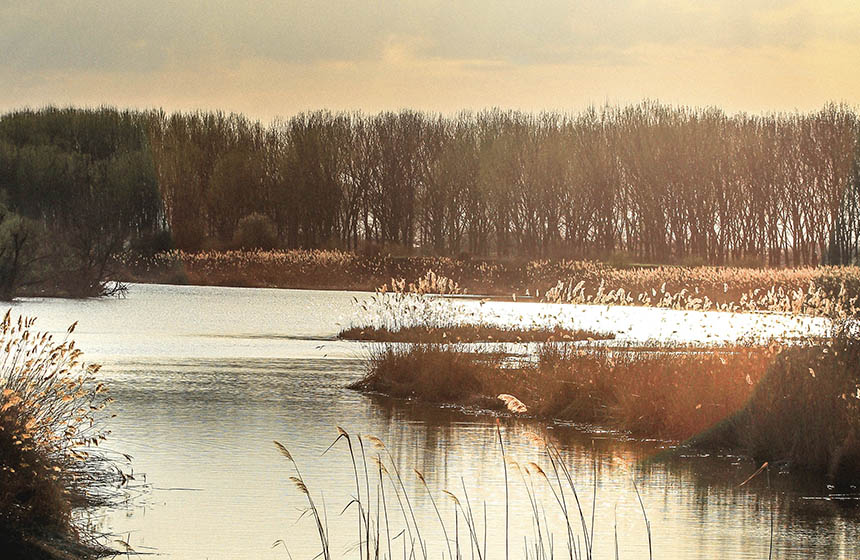
To manage flood risks to homes and businesses on the Steart peninsula, 300 hectares of farmland used for cattle grazing and arable crops were restored to intertidal habitats. As part of the Managed Realignment technique, new embankments were created a kilometre further inland and the old embankments were then removed (1). Over time, natural tidal processes created new channels and deposited silt and the seeds of salt-tolerant plants, restoring the original saltmarsh habitats. Farming intensity was reduced, and large areas of the reserve are now managed to stay wet.
The Steart Marshes are working wetlands, providing habitat for wildlife, flood protection for local villages, grazing land for low-intensity production of saltmarsh lamb and beef (including from Longhorn cattle), and nursery sites in saltmarsh creeks that support commercial fish stocks such as sea bass (1). In addition, wildfowling is permitted in three areas within the site (2).
Overview of context:
The Steart peninsula consists largely of low-lying farmland created on drained, reclaimed land and is at high risk of flooding (3). By 1997, however, coastal defences had deteriorated as a result of erosion and sea level rise (5). Sea level in the Severn Estuary is predicted to rise by another metre in the next 100 years, resulting in the loss of an area the size of 500 football fields, and increasing the pressure on man-made embankments (4). The Steart Marshes project was proposed by the Environment Agency, to compensate for losses of intertidal habitat elsewhere in the Severn Estuary, partly through ‘coastal squeeze’ due to sea level rise and partly due to development at the port of Bristol. Work began in 2011 and was completed in 2014. Steart Marshes is now one of the largest wetland reserves in the UK (2) and is part of a Site of Special Scientific Interest, Ramsar Site, and Special Protection Area. The marshes are managed by the Wildfowl and Wetland Trust (WWT), as a demonstration site to showcase the value of wetlands (4).
Case effectiveness on
Climate change
Saltmarsh habitats are expected to provide large stores of carbon (4). Research by Manchester Metropolitan University found that the restored marshes are currently sequestering 19 tonnes of carbon per hectare per year (6) (28), higher than most woodlands, although this rate may reduce over time. The study reported that emissions from the construction of the wetland were outweighed by carbon accumulation during the four year study period.
Low-lying land makes the area vulnerable to coastal flooding, which impacts houses and businesses (1). The Steart Marshes act as a buffer, absorbing wave energy from tides to protect the new embankments and nearby properties.
Ecosystem health
Ecological effect: PositiveDuring the construction of the wetlands, measures were undertaken to facilitate the movement of wildlife (4). For example, in 2011, a freshwater wetland was built on site to allow displaced amphibians and mammals to take refuge during construction. Badgers were moved to newly created setts and over 3,000 great crested newts were moved from intertidal areas to ponds in Steart village. Following construction of wetlands, the first shoots of salt tolerant plants were recorded in 2015. Wildlife monitoring recorded great crested newts, otters, butterflies, and wintering and breeding birds. In 2013, otter camera traps set up with local residents recorded a Eurasian otter near an artificial otter holt build by residents (7).
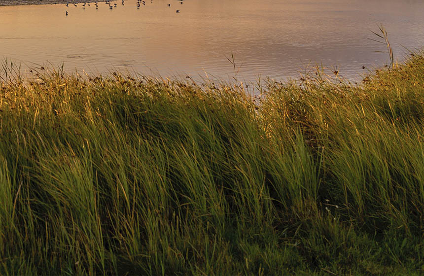
The Steart Marshes provide habitat for internationally and nationally important numbers of wintering wildfowl and migratory birds (2). Since 2015, avocets have been breeding on the site, with up to 40 pairs sighted each year (4). This was facilitated by the management of water levels in the landscape, allowing for muddy margins to support invertebrate life. In 2020, the only recorded pair of black-winged stilts in the UK that year bred successfully on site (8). WWT also worked with the Royal Society for the Protection of Birds as part of a conservation project for black-tailed godwits to release fledged chicks into breeding habitat. A released black-tailed godwit was spotted at Steart Marshes in 2017 (9). The site also provides connectivity to bird roost and food sites in the Somerset Levels. The site was designated as a National Nature Reserve in 2022.
The reserve’s freshwater ponds and streams support 18 species of dragonflies and damselflies, and were recognised as a Priority Site of National Importance for dragonflies in 2019 and as a dragonfly hotspot by the British Dragonfly Society in 2022 (4) (8).
Socioeconomic outcomes
The Steart Marshes are open all year round and have walking trails on paved paths with disabled access to hides and bird screens (3). Facilities on site include a mobile cafe and toilets (3). People can volunteer to guide tours, maintain the wetlands and manage the site, providing them with conservation and heritage skills (1). Most volunteers live in villages around Steart Marshes (4). Two community apple orchards were planted at the reserve in 2014, which will produce local varieties of apples as well as acting as a free venue for community events and supporting wildflowers and pollinators (10). As part of the Green Recovery Challenge in 2021, the local community, volunteers and staff were involved in a willow weaving community event to create a large sculpture of a longhorn cow (11). The number of people working on the land has increased from two to three people before the project to six full time staff and 60 volunteers (25).
Learning opportunities are provided for all ages and abilities, to understand the processes of the working wetland (12). A learning team at the Wetland Centre provides support to visitors, and resources developed by teachers and other educational experts are available online (13). WWT also works with Bridgewater College to provide environmental management training and student placements (14). In 2018, masters students from Bristol UWE used the reserve to learn techniques for habitat mapping, ecosystem service surveys, and saltmarsh assessment (15). A funded on-site wellbeing officer supports visitors to access health and wellbeing activities at Steart Marshes (25).
In addition to flood protection, Steart Marshes produce additional goods and services worth £0.5 to 1 million each year (1). It is expected that the marshes will attract visitors, supporting the local economy. A research project in collaboration with Oxford Brookes, Bridgewater College and WWT was initiated in 2014 to analyse the impact of the marshes on the economy and recreation (16).
Governance
Local participation in Governance: PassiveSteart Marshes is owned by the Environment Agency and is managed by the Wildfowl and Wetlands Trust. Villagers were involved at all stages of the project. During the planning stage, the Environment Agency consulted the local community and other stakeholders during monthly meetings (17). No objections were raised to the planning application, and landowners voluntarily sold their land (4). In addition, the name ‘Steart Marshes’ was chosen by residents.
Finance
The project was estimated to cost £20 million, and funds were sought from the government and other organisations (18). It eventually used £21 million of public funds, of which £7 million was used to buy land (24) (25). WWT secured a £1.58 million grant as part of the Government’s Green Recovery Challenge Fund to create and restore 130 hectares of wetland habitat along the Somerset Coast (19). A proportion of this grant was used from 2021 to 2022 to improve habitats within Steart Marshes, increase health and wellbeing opportunities for the local community and facilitate training sessions.
Monitoring and evaluation
Monitoring on site included surveys of plants and wildlife, water quality and archaeology. Archaeological monitoring was conducted during the excavation of new drains, finding Roman pottery from the 2nd to 4th century AD (4). Changes in plant communities across the three main wetland habitats (freshwater, brackish and saltwater) were surveyed in 2015 and 2018 as part of a National Vegetation Classification monitoring programme funded by the Environment Agency (20). The British Dragonfly Society trained members of staff and volunteers at Steart Marshes to survey dragonflies along set transects, recording species present, abundance and behaviour (defending territory, feeding, mating, laying eggs, or resting) (21). Water vole rafts were created to provide feeding stations or areas to mark territories, facilitating the capture of water vole activity on trail cameras and the analysis of droppings to understand their distribution (22). Ditch invertebrate surveys were conducted as a fast and resource-efficient way of monitoring invertebrates (6). Together with surveys by an ecological consultancy and DNA analysis, this found that most ditches scored “good” or “excellent”. Bat activity was also monitored across the site using AudioMoth detectors. Water quality surveys were also conducted twice a month with citizen scientists and volunteers, using nitrate and phosphate colour change kits. Funding from the Green Recovery Challenge fund enabled the systematic review of monitoring conducted on site, collating data from 2014 to 2020 (6). This enabled staff to understand the main knowledge gaps and plan future research. Scientific research being conducted on site was showcased using QR codes across the site in 2017, as part of a partnership between WWT and the University of West England (23).
Trade-offs and limitations
The project involved unavoidable trade-offs including the loss of fertile farmland, familiar landscapes and existing habitats such as trees and hedgerows (29). These and other concerns were partly addressed through effective community involvement (30), with residents appreciating the regular opportunities to express their views to the Environment Agency, the transparency of the operation, and the genuine changes of plans to address those concerns (29). Residents understood that the existing landscape could not be protected from sea level rise in the future, and that it was therefore preferable to implement the project in order to provide better protection for Steart village and the remaining farmland. Nevertheless, some farmers who sold their land ultimately lost out because they would not be able to buy the same area of land on higher ground, as it was more expensive (29). Also, although the area could attract more visitors, this is not always welcomed by local residents who value the tranquillity of the peninsula (29).
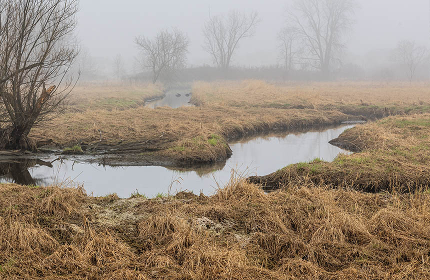
Managed realignment schemes have been found to result in erosion where the sea wall is breached, due to increased tidal flows. At Steart, the tidal channel rapidly increased in size for the first three months before stabilising and starting to accrete sediment, but a secondary channel is also forming so further erosion is likely before the whole area stabilises (26).
Some types of land may be easier to convert back to saltmarsh than others. A four year PhD study found that former pasture land appeared to re-colonise with saltmarsh vegetation and invertebrate species more rapidly than arable land, and that colonisation was also influenced by soil compaction (27), suggesting that minimising compaction due to project engineering activities could be beneficial.
References
- WWT. N.d. Creating Steart Marshes. https://www.wwt.org.uk/our-work/projects/creating-steart-marshes
- Burnham On Sea. N.d. Visiting Steart Marshes. https://www.burnham-on-sea.com/tourist-information/visiting-stert-island/
- National Trails. N.d. Somerset: Steart Marshes Circular. https://www.nationaltrail.co.uk/en_GB/short-routes/steart-circular/
- WWT. N.d. Steart Marshes. https://www.wwt.org.uk/wetland-centres/steart-marshes/
- Environmental Agency. 2002. Stolford to Combwich coastal defense strategy study volume 1. https://web.archive.org/web/20070927182252/http://www.environment-agency.gov.uk/commondata/acrobat/stolford_to_combwich.pdf.pdf
- WWT. 2022. GRCF monitoring and citizen science Steart Marshes. https://www.wwt.org.uk/wetland-centres/steart-marshes/news/grcf-monitoring-and-citizen-science-steart-marshes
- WWT. 2013. Otter snapped at Steart for the first time. https://www.wwt.org.uk/wetland-centres/steart-marshes/news/otter-snapped-at-steart-for-first-time
- WWT. N.d. Wildlife at Steart Marshes. https://www.wwt.org.uk/wetland-centres/steart-marshes/wildlife-at-steart-marshes/#tab_summer3_1
- WWT. 2017. Released black-tailed godwit seen at WWT Steart Marshes. https://www.wwt.org.uk/wetland-centres/steart-marshes/news/released-black-tailed-godwit-seen-at-wwt-steart-marshes
- WWT. 2014 Community orchards planted at Steart. https://www.wwt.org.uk/wetland-centres/steart-marshes/news/community-orchards-planted-at-steart
- WWT. 2021. Giant willow longhorn community project at Steart Marshes. https://www.wwt.org.uk/news-and-stories/news/giant-willow-longhorn-project-at-steart-marshes
- WWT Learning Zone. N.d. Learn at Steart Marshes. https://learningzone.wwt.org.uk/steart-marshes/
- WWT Learning Zone. N.d. Resources. https://learningzone.wwt.org.uk/explore-resources/
- WWT. N.d. Learning at Steart Marshes. https://www.wwt.org.uk/wetland-centres/steart-marshes/visiting-steart-marshes/learning-at-steart-marshes/
- WWT. 2018. Bristol UWE field trip. https://www.wwt.org.uk/wetland-centres/steart-marshes/news/bristol-uwe-field-trip
- WWT. 2014. Steart Marshes study to analyse impact on economy and recreation. https://www.wwt.org.uk/wetland-centres/steart-marshes/news/steart-marshes-study-to-analyse-impact-on-economy-and-recreation-2
- Environment Agency. 2012. The Steart Peninsula Project. https://web.archive.org/web/20121203134722/http://www.environment-agency.gov.uk/homeandleisure/floods/80793.aspx
- BBC. 2010. Plans to flood Steart peninsula to create wetlands. https://www.bbc.co.uk/news/10513811
- WWT. 2021. Grant secured to protect and enhance the Somerset coast. https://www.wwt.org.uk/wetland-centres/steart-marshes/news/the-green-recovery-challenge-fund
- WWT. 2018. Monitoring plant changes over time. https://www.wwt.org.uk/wetland-centres/steart-marshes/news/monitoring-plant-changes-over-time
- WWT. 2018. Dragonfly training. https://www.wwt.org.uk/wetland-centres/steart-marshes/news/dragonfly-training
- WWT. 2018. Water vole monitoring. https://www.wwt.org.uk/wetland-centres/steart-marshes/news/water-vole-monitoring
- WWT. 2017. Science behind Steart – New QR codes on reserve. https://www.wwt.org.uk/wetland-centres/steart-marshes/news/science-behind-steart-new-qr-codes-on-reserve
- BBC. 2014. Steart Peninsula’s £21wetland habitat opens. https://www.bbc.co.uk/news/uk-england-somerset-26952881
- Rewilding Britain. N.d. Steart Marshes. https://www.rewildingbritain.org.uk/why-rewild/rewilding-success-stories/case-studies/steart-marshes
- Pontee, N. I. and Serato, B. 2019. Nearfield eroison at the steart marshes (UK) managed realignment scheme following opening. Ocean & Coastal Management 172:64-81. https://www.sciencedirect.com/science/article/abs/pii/S0964569117310505
- George, A. J. 2020. Ecological community changes and ecosystem functioning during structured wetland development. Oxford Brookes University. https://core.ac.uk/download/pdf/424580304.pdf
- Mossman, H. L., Pontee, N. Born, K., Hill, C., Lawrence, P. J., Rae, S., Scott, J., Serato, B., Sparkes, R. B., Sullivan, M. J. P. and Dunk, R. M. 2022. Rapid carbon accumulation at a saltmarsh restored by managed realignment exceeded carbon emitted in direct site construction. PLoS ONE 17:e0259033. https://journals.plos.org/plosone/article?id=10.1371/journal.pone.0259033
- Yamashita, H., Mikami, N., Mcinnes, R. and Everard, M. 2019. Community perceptions towards risks and benefits of a saltmarsh restoration project: Learning from a case study in the UK. 7th International Symposium on Environmental Sociology in East Asia (ISESEA) Graduate School of Environmental Studies, Seoul National University, Seoul, Korea. https://uwe-repository.worktribe.com/index.php/preview/2614338/2019.10.26.ISESEA.Seoul.UK%27s%20learning%282019.08.29%29.pdf
- Scott, J., Pontee, N., McGrath, T., Cox, R. and Philips, M. Delivering large habitat restoration schemes: Lessons from the Steart Coastal Management Project. https://www.icevirtuallibrary.com/doi/epdf/10.1680/cm.61149.663
Intervention type
- Created habitats
- Food production
- Management
- Restoration
Ecosystem type
- Saltmarsh
- Wetlands
Climate change impacts addressed
- Freshwater flooding
- Coastal inundation
- Storm surge
Instigators
- National conservation/environment organisation
- National government/agency
Societal challenges
- Biodiversity conservation
- Climate change adaptation
- Climate change mitigation
- Disaster risk reduction
- Economic and Social development
- Food security
- Health
Outcomes
- Food security: Positive
- Water security: Not reported
- Health: Positive
- Local economics: Not reported
- Livelihoods/goods/basic needs: Not reported
- Energy security: Not reported
- Disaster risk reduction: Positive
- Rights/empowerment/equality: Not reported
- Recreation: Positive
- Education: Positive
- Conflict and security: Positive
- No. developmental outcomes reported: 8
Resources
Read resource 1Literature info
- Grey literature
- Peer reviewed
Similar cases by ecosystem
-
Restoration of wet grassland, reedbed, and fen in the Greylake Nature Reserve
Conversion of arable farmland to wet grassland, reedbed, and wet fen aims to restore biodiversity in the Greylake Nature Reserve and increase the area’s carbon storage potential and adaptive capacity in the face of flooding.
United Kingdom -
Peatland restoration to protect water supplies in the Garron Plateau
Activities to restore the Garron Plateau containing the largest area of peat bog in Northern Ireland began in 2010 after 95% of the bog had been degraded.
United Kingdom