Wild Ennerdale: a landscape-scale partnership to reduce farming intensity and restore natural processes
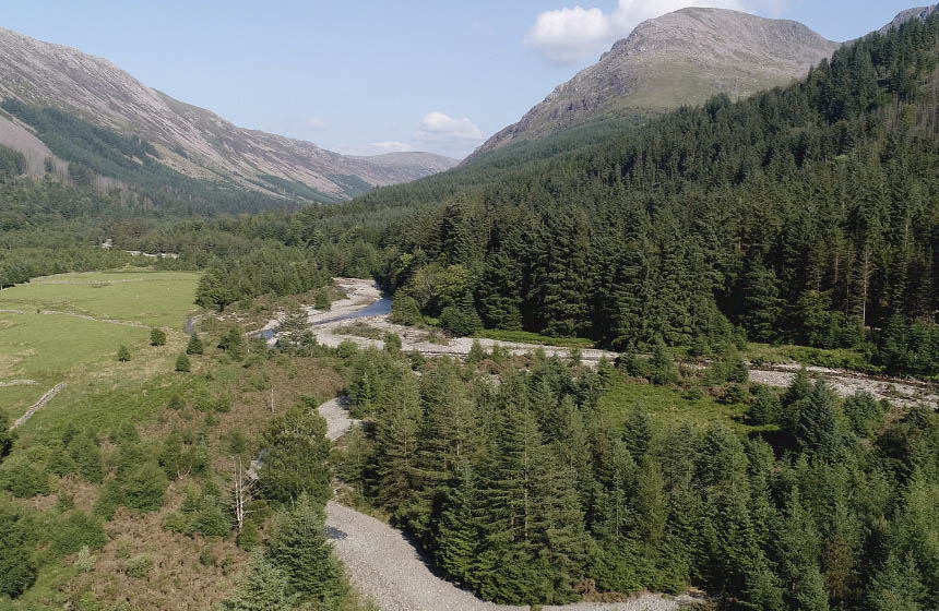
Boundaries between landowners in Ennerdale valley have resulted in stark contrasts in land uses. Now, partnerships between these organisations facilitate the co-operative landscape restoration and management of the second largest National Nature Reserve in Cumbria, spanning 4,400 hectares.
Nature-based intervention:
During the Mesolithic and Neolithic periods, the Ennerdale valley was predominantly covered in oak, alder, and birch woodlands. Forest clearings in the valley can be traced as far back as 3200 BC, and the subsequent practice of pastoral farming hindered the regrowth of trees. The Wild Ennerdale partnership aims to foster a sense of ‘wildness’ of the landscape and allow natural processes to change the valley. In this approach, farming practices continue at a reduced intensity with considerations for maximising ecology. For example, grazing approaches have been modified to use low-density year-round grazing with black Galloway cattle to mimic disturbances caused by the native herbivores that once existed on the landscape (1). Other initiatives involve the removal of river barriers, targeted species conservation approaches to benefit Arctic Char, juniper, the Marsh Fritillary butterfly and Red Squirrels, the removal of mature non-native conifers to facilitate a mixed-species forest, and the creation of the ‘Wild Ennerdale’ brand to increase tourism and support local livelihoods.
Overview of context:
Ennerdale valley is 14.5 km long and 5.6 km wide, surrounded by mountain peaks reaching 900 m. Historical land use includes sheep grazing and commercial forestry (2). Land management strategies differed among the three main landowners in the valley, the Forestry Commission, National Trust, and United Utilities, resulting in sharp boundaries and stark contrasts in land uses (3) However, the three landowners formed a partnership in 2002 to cooperatively manage land. The broader Lake District, encompassing Ennerdale, has been recognised as a World Heritage Site due to its cultural landscapes shaped by human society and natural processes (4).
Case effectiveness on
Climate change
While data on overall carbon sequestration has not yet been reported, it is expected that the increase in trees planted across the valley and the restoration of wetland ecosystems may contribute to increased sequestration (5).
Mature non-native conifer trees are being gradually removed from the site to facilitate the growth of mixed native broadleaf and conifer forest. Wild Ennerdale reports that the mixed forest structure is likely to facilitate enhanced resilience to climate change impacts (6). In addition, efforts to control river flow and prevent riverbank erosion with engineered structures have been abandoned, allowing re-establishment of a natural system where trees regularly fall into the river, creating woody debris, meanders and gravel banks. After a major storm in 2009, it is reported that reservoirs in North Cumbria became too polluted with sediment to supply drinking water, but in Ennerdale the rewilded river system prevented sediment flowing into the lake, allowing it to supply clean drinking water as usual (8).
Ecosystem health
Ecological effect: PositiveManagement of the site to restore ecosystems ranges from natural regeneration to tree planting and species reintroductions. For example, in some areas where conifer plantations have been felled, trees are left to naturally regenerate, and in others, such as Black Sail and Proud Knott, native species are planted. Over 100,000 native trees have been planted across the valley, including 10,000 juniper plants, a rare species (the name Ennerdale comes from the Old Norse for juniper). Invasive species management includes the removal of rhododendron and its replacement with native woodland (3).
Targeted species conservation measures have contributed to increases in population numbers. Once declared extinct in Cumbria, the Marsh Fritillary butterfly populations in Ennerdale are now regarded as England’s largest and most sustainable population (3). This was reportedly due to the habitat restoration and reintroduction initiatives led by Butterfly Conservation and Natural England (7).
Similarly, numbers of adult spawning Arctic Char in Ennerdale (the last surviving river spawning Char in England) have declined to just a few individuals due to factors such as acid flushes and barriers formed by crude pipe bridges (8).The bridges not only prevented fish from migrating upstream but also stopped gravel from being washed from a side-stream into the main river, preventing formation of the gravel beds where the fish spawn. In 2005, the Environment Agency and Wild Ennerdale removed barriers and restocked with reared fish, resulting in an increase in Char populations to over 300 fish (1).
Red grouse populations have also faced declines in the valley, reportedly due to heath and blanket bog fragmentation, predation, overgrazing, grouse shooting, and diseases (9). However, there has been an observed increase in red grouse group territories discovered during surveys in 2022 (10).
An outbreak of the disease Phytopthora Ramorum that affected Larch trees across 60 hectares of forest was identified in 2021 (11). From 2022 to 2023, tree felling and harvesting work was initiated to minimise the spread of the disease. Prior to felling trees, wildlife surveys are conducted, and if squirrel dreys or bird nests are present, the trees are left standing and felled after the breeding season or killed on the spot using herbicide application. Monitoring of the sites continues following felling.
In addition to ongoing projects, Wild Ennerdale has proposed other potential ecological changes for implementation. To achieve a healthy river ecosystem and support mussel populations in River Ehen, Wild Ennerdale aims to facilitate the natural regeneration of scrub and woodlands to improve soil health, plant native trees to prevent water run-off and provide species with habitat and resources, install leaky willow dams to capture silt and nutrient run-off, and remove old infrastructure that may cause river blockages (6). In 2018, beaver re-introductions were proposed, but assessments indicated that the dynamic nature of the river Liza makes the site unsuitable for re-introductions (6). A 2020 independent ecology feasibility study revealed that the valley is suitable for beaver release, but following further consultations the plans are currently on hold (see Trade-offs).
Socioeconomic outcomes
Maintaining the cultural legacy of the site is an important feature of the partnership. This is especially pertinent given that over 500 archaeological sites have been identified, many of which are of regional and national importance (12). In addition, the 2006 stewardship plan explicitly identifies that human activity is an important part of the landscape and that initiatives should have socio-economic benefits (2).
However, a 2012 study highlighted that such programmes to create wild landscapes may drive communities away from the land and lead to a loss of traditional land management skills (13).
Much of the work on site is carried out by volunteers, and there is an active engagement programme, hosting an average of four visits per month in 2023 from government agencies, wildlife groups, community organisations, schools and universities (20).
Governance
Local participation in Governance: ActiveInitially, land management in Ennerdale involved separate management by different landowners, as outlined in the 1996 Forestry Commission Ennerdale Forest Design Plan. However, the establishment of the Wild Ennerdale partnership among three primary landowners in 2002 led to a shift. The Stewardship Plans in 2006 and 2018 delineate a landscape-scale management strategy characterised by cooperative efforts. Currently, the partnership comprises two governmental bodies, Forestry Commission and Natural England, a charity, National Trust, and a private utility company, United Utilities (1).
Wild Ennerdale Partners consult individuals and organisations that have a vested interest in the management of Ennerdale (14). These include local organisations, community members, and visitor groups.
An interesting example of unexpected governance benefits from rewilding is reported, where removal of a fence bordering a river allowed a tenant farmer to let his cattle wander across the whole valley. This removed the stress of trying to prevent the river bank from erosion, which was previously eating into his grazing land, and also removed a source of tension between the farmer and the landowner who was responsible for maintaining the gabions that protected the bank (8).
Finance
Projects are funded through grants. For example, programmes to plant native trees and trap grey squirrels were funded through the European Outdoor Conservation Association (15). Funding through grants is also available through initiatives in the wider Cumbria landscape. For example, funding was received through the Cumbria County Council Community Grant.
Monitoring and evaluation
Wild Ennerdale monitor wildlife populations on the site in partnership with local council and community groups. For example, red squirrel populations are monitored each Spring and Autumn, and grey squirrels are trapped and removed. In addition, changes to habitats are documented using methods to monitor continuous cover transformation, surveys, and fixed point photographs. Innovative approaches to monitoring include a multibeam sonar system called DIDSON, which allows migrating Char to be counted at night without using bright lights, which disturb the fish. This is used in parallel with hydro-acoustic technology in the lake (8). Reports from monitoring are detailed on the Wild Ennerdale website (16).
Two stewardship plans have been established to date, in 2006 and in 2018. Progress on the actions have been detailed in the Review of Actions and Achievements document (17).
Trade-offs and limitations
While the removal of non-native sitka spruce plantations may support a move towards a natural ecosystem type, it may result in the removal of habitats for wildlife and current carbon storage. Hence, Wild Ennerdale prioritise the gradual removal of mature conifers to facilitate broadleaf woodland in a mixed-forest habitat type (11).
Beaver reintroductions proposed by Wild Ennerdale have been controversial, with opponents citing obstruction risks posed from enclosure fencing for beavers, the large financial investments required, and negative characteristics of beavers which may pose threats to visitors and their pets (18). Plans for a fenced beaver enclosure have been dropped because it would pose an obstruction to migrating fish, although the long-term aim for free-living beavers remains (20).
While the removal of barriers between landowners’ properties has allowed for a concerted management strategy between organisations, also allowing cattle to graze over larger distances, it reportedly has implications for the safety and protection of farmers’ sheep. Farmers raised concerns that sheep may be harmed when allowed to roam freely, resulting in injury or disease (13).
The overall objective of Wild Ennerdale to limit management and restore natural processes means that there are no fixed endpoints as a goal (19). This has led to criticism from the public that project approaches are unclear (13).
References
- Wild Ennerdale. 2018. Stewardship plan 2018-2020. https://www.wildennerdale.co.uk/wp-content/uploads/2019/02/wesp-final-11-2018.pdf
- Wild Ennerdale. 2006. Wild Ennerdale stewardship plan. https://www.wildennerdale.co.uk/wp-content/uploads/2013/02/Stewardship-Plan-Text.pdf
- Wild Ennerdale. 2018. Stewardship plan 2018 combined maps. https://consult.forestryengland.uk/forest-districts/wild_ennerdale/supporting_documents/Combined%20maps.pdf
- Lake District National Park. N.d. What is a World Heritage Site? https://www.lakedistrict.gov.uk/caringfor/whs/what-is-a-world-heritage-site
- Wild Ennerdale. 2022. Wild Ennerdale – Climate. https://www.youtube.com/watch?v=EpvVmOfCDfE
- Wild Ennerdale. 2018. Stewardship plan consultation summary response July 2018. https://www.wildennerdale.co.uk/wp-content/uploads/2019/03/wild-ennerdale-stewardship-plan-consulation-responses-summary.pdf
- Doyle, S. 2008. The Marsh Fritillary project. https://www.cumbria-butterflies.org.uk/conservation/marsh_fritillary/
- Browning, G. and McCullough, P. 2015. Re-wilding and giving Ennerdale Arctic charr a helping hand. Institute of Fisheries Management magazine. https://www.wildennerdale.co.uk/wp-content/uploads/2013/02/Wild-Ennerdale-IFM-Magazine-2015-re-wilding-and-Giving-Artic-Charr-a-helping-hand.pdf
- Wild Ennerdale. 2007. Red grouse Lagopus lagopus scoticus survey March 2007. https://www.wildennerdale.co.uk/wp-content/uploads/2013/02/Wild-Ennerdale-Red-Grouse-Survey-2007.pdf
- Wild Ennerdale. 2022. Autumn Newsletter. https://www.wildennerdale.co.uk/wp-content/uploads/2022/11/WildEnnerdaleRedGrouse-2022-draft-2.pdf
- Wild Ennerdale. N.d. Forest. https://www.wildennerdale.co.uk/managing/forest/
- Wild Ennerdale. N.d. Archeology. https://www.wildennerdale.co.uk/managing/archaeology/
- Convery, I. and Duston, T. 2012. Wild Ennerdale: A Cultural Landscape. Pp 233-250 in Forest Landscape Conservation. https://link.springer.com/chapter/10.1007/978-94-007-5326-6_12
- Wild Ennerdale. 2011. Stewardship plan review liaison group feedback June 2011. https://www.wildennerdale.co.uk/wp-content/uploads/2013/02/wild-ennerdale-liaison-group-2011-summary-of-feedback.pdf
- European Outdoor Conservation Association. N.d. Wild Ennerdale. https://www.eocaconservation.org/projects/wild-ennerdale/
- Wild Ennerdale. N.d. Monitoring. https://www.wildennerdale.co.uk/managing/monitoring/
- Wild Ennerdale. 2018. Wild Ennerdale Stewardship Plan 2018 – Appendix 2: Review of actions and achievements 2006 to 2018. https://www.wildennerdale.co.uk/wp-content/uploads/2019/02/Appendix-2-Actions-Achievements.pdf
- Rodgers, M. 2023. Objection to the Wild Ennerdale vision to reintroduce Eurasian beavers to Ennerdale and the River Ehen Cumbria. https://committees.parliament.uk/writtenevidence/115872/pdf/
- Wild Ennerdale. N.d. Stewardship plan. https://www.wildennerdale.co.uk/managing/stewardship-plan/
- Wild Ennerdale. 2023. Winter newsletter. https://www.wildennerdale.co.uk/wp-content/uploads/2023/04/wild-ennerdale-newsletter-winter-2023.pdf

Intervention type
- Created habitats
- Management
- Protection
- Restoration
Ecosystem type
- Temperate forests
- Peatland
- Streams, rivers, riparian
Climate change impacts addressed
- Drought
- Freshwater flooding
Instigators
- Local NGO or CBO (eg. indigenous)
- National conservation/environment organisation
- National government/agency
Societal challenges
- Biodiversity conservation
- Climate change adaptation
- Water security
Outcomes
- Food security: Not reported
- Water security: Positive
- Health: Not reported
- Local economics: Not reported
- Livelihoods/goods/basic needs: Not reported
- Energy security: Not reported
- Disaster risk reduction: Positive
- Rights/empowerment/equality: Not reported
- Recreation: Unclear
- Education: Not reported
- Conflict and security: Not reported
- No. developmental outcomes reported: 4
Resources
Read resource 1Literature info
- Grey literature
- Peer reviewed


