North East Cotswold Farmer Cluster: Landscape-scale nature recovery on farmland
North East Cotswold Farmer Cluster: Landscape-scale nature recovery on farmland
The North East Cotswold Farmer Cluster is a network of farmers, growers, landowners, foresters, and advisors who share knowledge and collaborate on landscape-scale regeneration of farmed environments in the North East Cotswolds.
Nature-based intervention:
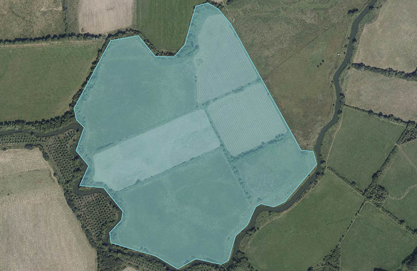
Collectively, the group of over 161 farmers and landowners covers 47,600 hectares (1). To improve natural capital and address climate change while facilitating resilient food and farming businesses, the group collaborates to achieve six main objectives: i) improve soil health, ii) monitor, create, and connect priority habitats, iii) grow the local food economy through innovative practices, iv) access private investment and public funding opportunities, v) monitor outcomes at multiple scales, and vi) engage with communities. The Cluster is working on a variety of projects, all of which are laying the groundwork for their flagship Evenlode Landscape Recovery project, a 20 year vision for landscape restoration that is part of Defra’s Environmental Land Management scheme (15). This will focus on improving river health, reducing flooding and improving biodiversity. It initially targets riparian land parcels in the Evenlode and Windrush valleys that cover 14% of the area, through actions such as floodplain meadow and river restoration.
Habitat restoration across the catchment will include arable reversion to grassland, creation and restoration of wetlands, ponds, watercourses and traditional orchards, and tree planting in carefully selected locations. A pilot ‘One field’ project (2) modelled the potential financial benefits of different potential options for a single arable field that frequently floods, and developed a progressive conversion strategy with flexible endpoints that can be determined by the landowner. From an arable baseline, the project can move to no till, then reversion to agricultural grass, herbal ley, floodplain meadow, and lastly to a floodplain habitat mosaic. Benefits for soil, carbon, water quality and biodiversity increase significantly at each step, for a minimal reduction in food production (3). Other measures considered as part of the Landscape Recovery project include redirecting water from natural springs and underdrainage networks to create floodplain habitats (4), creating multi-threaded river systems (5), and restoring straightened and embanked river channels to their historical sinuous pathways (6). Targeted support for species includes wildflowers for pollinators, winter feeding of wild birds, creation of fish and eel passes, and floodplain restoration for wading birds.
Overview of context:
Farmer Clusters are local groups of farmers and other landowners or land managers who work together on common goals, helping them to share knowledge and attract more funding. There are over 100 clusters in the UK, and although the North East Cotswolds cluster was only established in 2020 it has grown rapidly to become one of the largest in the country. It is based around the Evenlode and Windrush catchments in the Thames Valley and the Cotswolds National Landscape (formerly ‘Area of Outstanding Natural Beauty’) (7), aiming to facilitate landscape-scale environmental projects using a bottom-up governance approach (9). In common with many lowland agricultural regions, the area has undergone widespread conversion of grassland to arable land since 1945 (8) and now suffers severe problems with soil erosion, flooding, poor water quality and biodiversity loss, which the project aims to help tackle in partnership with other organisations.
Case effectiveness on
Climate change
The project is creating a financial model that will support increased carbon sequestration on farmland. Baseline surveys of soil carbon were conducted in 2022 from 36 farms across 15,000 hectares, in partnership with Rothamsted Research Institute. Soil organic carbon measurements will be compared across 22 different soil types and a range of crop types and management strategies (9). This information will be used to develop plans to increase carbon sequestration, model impacts of regenerative practices on soil carbon sequestration, and participate in the ISO accredited Greenhouse Gas emissions scheme to monetise carbon (10). Preliminary data from 1,300 samples after six months of baselining demonstrate that pasture land has higher carbon stocks than arable land across all sample farm sites, and the higher levels of organic matter were associated with lower soil bulk density, indicating higher soil health (11). As such, measures underway to convert arable land to grassland are expected to lead to increased carbon storage as well as to reduce carbon loss via soil erosion.
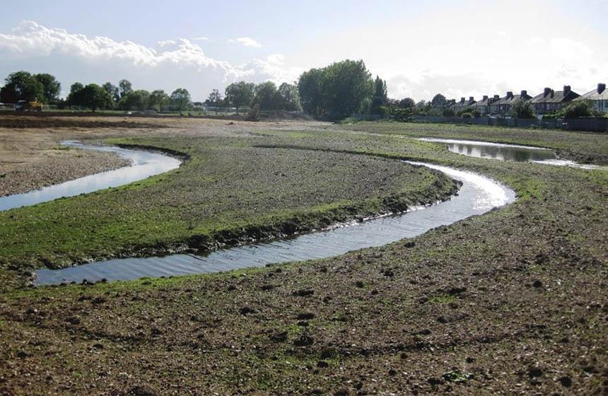
The Evenlode Landscape Recovery Project is specifically targeted at increasing the resilience of local farms and communities to climate change, especially through Natural Flood Management (NFM). This will be achieved by creating and restoring 3,271 hectares of habitats in the Evenlode Valley, including close to 1,000 hectares of floodplain, creating, regenerating and managing over 600 hectares of woodland, and restoring 380 hectares of waterscapes (12). Existing initiatives by cluster partners, some of which pre-date the formation of the cluster, include restoring 30 hectares of arable land to wetlands, floodplain meadows, riparian scrub and woodland, and restoring 1 km of the River Evenlode at Pudlicote Farm (13). This initiative was found to significantly reduce the risk of soil loss into the river (14). Monitoring and implementation of the Landscape Recovery project will run for 20 years, but it is reported that wetland restoration through this project has already prevented the inundation of local villages and the drowning of crops (15).
Efforts to increase soil organic carbon sequestration are also considered in concert with initiatives to increase soil health, allowing for increased soil moisture retention, which has the potential to increase resilience to droughts and minimise flooding (16).
Ecosystem health
Ecological effect: PositiveThe project specifically targets increased biodiversity, funded by grants, agri-environment schemes and by selling Biodiversity Net Gain (BNG) offsets to developers and infrastructure developers. For example, a BNG assessment prior to implementation of the Pudlicote scheme, using the Natural England beta-test Biodiversity Metric 2.0 (17), estimated that restoring arable land to meadow and grassland habitats and creating wetlands would result in a net gain of 94 BNG units. Once implemented, this initiative was reported to have improved habitat and spawning areas for fish and connectivity between the river and its floodplain (14). Similarly, projects on five farms in Lyneham created 18 hectares of wildflower meadows for pollinators and enhanced 6 hectares of existing meadows, created new spring-fed ponds and wetlands for aquatic life, improved habitat connectivity to an ancient woodland, and created new fish passages using ‘water jumps’. In addition, reedbeds were created to intercept sediment and nutrient from arable runoff, to improve water quality (18). In future, it is hoped that river restoration will increase endangered populations of water vole and eels, the latter being valuable as predators of the invasive Signal Crayfish.
Bird feed produced on farms within the Cluster is used for supplementary feeding of farmland birds during winter (19). Farmland bird surveys were conducted by researchers from WildCRU and the University of Oxford’s Department of Biology, comparing feeding sites and non-feeding sites. While results are not yet published, a 2023 survey at a feeding site showed large numbers of birds visiting in a 30 -minute recording period, including 130 yellow hammers, 460 linnets, 100 chaffinch, 13 reed buntings, 25 goldfinch, and one brambling. At FarmED, a demonstration farm in the centre of the area, the number of bird species doubled to reach a high of 84 species, attributed to habitat creation and the supplementary feeding programme (9).
Socioeconomic outcomes
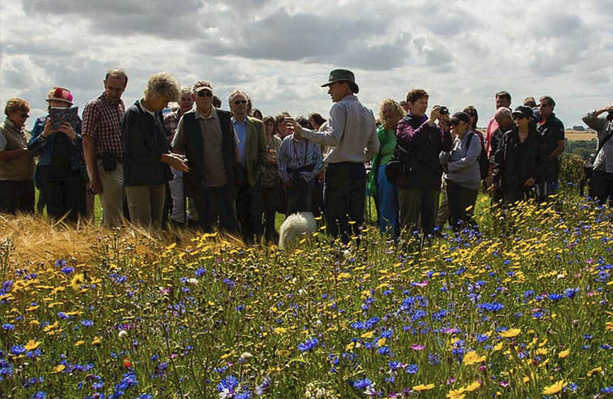
The Cluster is led by local farmers and has explicit aims to build capacity among farming neighbours and contemporaries. In line with this, the Cluster organises lectures, farm visits, practical workshops, farm management briefings, and regional gatherings to connect members of the network together (20). This is greatly facilitated by the presence of FarmED, a demonstration farm and education hub at the centre of the project area, which is used as a venue for events and training. Many of the cluster members also host smaller events on their farms. Members have said that being a part of the Cluster gives them the confidence to apply new techniques and provides them with better access to funds and resources. At AGM meetings, feedback on the initiatives and priorities are sought from cluster members and followers.
Although habitat creation on farmland can reduce the area of land available for food production, impacts are minimised by targeting areas where food production is marginal, e.g. places that often flood. In addition, the Cluster explicitly aims to support local food markets and help farm businesses to become more resilient to environmental and socio-economic pressures, such as by reducing flooding and improving soil health, which can safeguard food production in the long term. By grouping together, the farms have greater bargaining power with supermarkets and can also explore new markets. For example, plans are underway to capitalise on increased deer numbers across the Cluster area by tapping into the market for venison (21). To facilitate this, a drone survey of deer populations will be conducted in 2024 and current venison supply chains will be analysed to inform how the Cluster can gain monetary value from deer populations. The Cluster is also supporting local food production by campaigning against the closure of the local abattoir.
Governance
Local participation in Governance: ActiveThe Cluster is a Community Interest Company (CIC) comprising a group of local farmers and landowners with three directors, two facilitators, and a six-member advisory group (3). To join as a ‘Farmer Member’, with access to discussion sessions, projects and collective funding, landowners are requested to pay 1 pound per hectare per annum (22). Alternatively, advisors, NGOs and other stakeholders can join for free as a ‘Farmer Follower’ or ‘Friend’, who can attend selected group events and receive updates. The group works closely with other organisations in the area, including the Evenlode Catchment Partnership (ECP), FarmED, and the Heritage Wheat Group, as well as national agencies. For example, during the design of the Pudlicote floodplain restoration scheme, the landowner partnered with specialists including the Environment Agency, Natural England, Cotswolds Seeds and the Forestry Commission, with a total of 25 people consulted (17).
Finance
The Cluster applies for different projects and grants to fund restoration projects and support facilitation (20). Agri-environment schemes are a key source of funding. The cluster was awarded £500,000 of government funding to establish the Evenlode Landscape Recovery project as part of Defra’s Environmental Land Management scheme. Defra’s Farming in Protected Landscapes programme provided funding for habitat creation in Lyneham between 2021 to 2024, the restoration of the Windrush floodplain meadows between 2022 to 2024, and the supplementary feeding of farmland birds (18) (19). The Pudlicote habitat restoration project provided the basis for a ‘habitat bank’ owned by the landowner that could sell Biodiversity Net Gain projects to developers and infrastructure providers.
The Cluster also initiated a project with Rothamsted Research and Oxbury Bank, funded by an 18-month grant from the Natural Environment Investment Readiness Fund (administered by the Environment Agency on behalf of Defra) to develop financial products and services that ‘bridge the gap’ by supporting farmers to pay for upfront costs of natural capital improvement, thus enabling future income streams from ecosystem service payments (23).
Monitoring and evaluation
The project is devoting significant effort to establishing robust baselines against which to measure future outcomes. Baseline information on rivers, wetlands, meadows and grasslands, and woodlands was collected and mapped prior to landscape restoration efforts in the Evenlode Catchment and have been developed into an online data portal that sets the strategic direction for any interventions in the catchment (23). Maps of land cover change since 1945 were also compiled for the catchment area (8). Projects use innovative survey techniques to inform restoration initiatives. For example, ground-based LiDAR scans were used to assess the historic course (palaeochannel) of straightened rivers, to inform restoration plans (6).
For monitoring soil organic carbon, standard methods include ‘loss on ignition’, or the more expensive but more precise DUMAS method, but these both require off-site laboratory analysis. To provide quicker and cheaper on-site estimates, handheld near infrared spectrometers (Neospectra) were used (24) – a strategy developed by Rothamsted Research. Some fields have been measured using both laboratory analysis and the handheld scanners, while others have only used the scanners, and some have not been measured (16). The combined datasets have been used to generate a calibration curve with estimates of uncertainty and error to estimate total carbon stocks across the cluster.
Monetary benefits from restoration have been assessed at the planning stage for several initiatives. For example, the One Field pilot project (2) calculated the potential financial benefits of a progressive transition from arable cereal cropping to a mosaic of habitats on a farm that floods regularly. Impacts of these changes on soil loss, carbon capture, nutrient retention, water retention, knowledge transfer, and biodiversity were calculated using a natural capital and ecosystem services approach, finding that the loss in food production was eight times less than the financial gain from habitat recovery. Given the benefits, these changes are being implemented both on the modelled field and on other fields in the cluster. A similar assessment for the Pudlicote scheme estimated monetary benefits over 25 years from food production, air quality, water quality, flow regulation, erosion regulation, climate regulation, pollination potential, and recreation (13). Using a conservative valuation approach to account for uncertainty in the assumptions, this estimated that every £1 spent on delivery could generate £6 in benefits.
Strategies for effective landscape recovery are being tested and developed using pilot sites. For example, baseline data on biodiversity is being collected on the sites for five flagship projects to restore species-rich grassland as part of the Windrush Floodplain Meadows Restoration project. Learnings from these five sites will then be used to create a floodplain meadow management and restoration strategy (25).
Trade-offs and limitations
Management options for increasing soil carbon in cropland can have positive impacts on climate change mitigation but may have tradeoffs. For example, arable/pasture rotation can support carbon sequestration and soil health, but results in less arable crop production alongside more livestock production.
The supplementary feeding project enhanced bird numbers on feeding sites compared to control plots, but this only tells us that the birds are attracted to sites providing food (26). Future research will analyse the landscape-level impacts of supplementary feeding by comparing farming practices across farms, which may help to reveal the relative importance of supplementary feeding versus sustainable farming practices to facilitate long-term resilience in bird populations. However, in the short-term, supplementary feeding can attract large numbers of birds to the farm which could shift farmer perspectives on their relationship with birds and their value to farms.
References
- North East Cotswold Farm Cluster. N.d. About us. https://www.cotswoldfarmers.org/about
- Atkins. N.d. One Field. https://www.cotswoldfarmers.org/lr-1
- South East Farmer. 2024. Environmental health and restoration a common theme. https://www.southeastfarmer.net/features/environmental-health-and-restoration-a-common-theme/
- North East Cotswold Farm Cluster. N.d. Source protection. https://www.cotswoldfarmers.org/lr-3
- Atkins. N.d. Stage 0. https://www.cotswoldfarmers.org/lr-4
- North East Cotswold Farm Cluster. N.d. Re-meander it. https://www.cotswoldfarmers.org/lr-5
- North East Cotswold Farm Cluster. 2021. Farmer-led projects to enable landscape scale ecosystem recovery. https://floodplainmeadows.org.uk/sites/default/files/resources/Farmer-led%20projects%20to%20enable%20landscape%20scale%20ecosystem%20recovery%20%28Tim%20Field%29.pdf
- North East Cotswold Farm Cluster. 2023. Land use change in the Evenlode catchment. https://drive.google.com/file/d/1gbFXh0oShoK_02Q_qe5NeWSVC8lg2i-Q/view
- Agricology. N.d. North East Cotswold Famer Cluster CIC. https://agricology.co.uk/research-projects/north-east-cotswold-farmer-cluster-cic/
- North East Cotswold Farm Cluster. N.d. Soil carbon baselining (Completed – Dec 2022). https://www.cotswoldfarmers.org/soil-carbon-baselining
- East of England Agricultural Society. 2022. The Carbon Conversation part of the Shuttleworth Series. https://www.youtube.com/watch?v=JEdiY6qtinY&list=PLWTgP69uJo05aFv_-Nqb3Nro3ypIJBpB-&index=1
- Blenheim Estate. N.d. Local farmers join forces with our estate. https://www.blenheimestate.com/news/local-farmers-join-forces.html
- North East Cotswold Farm Cluster. N.d. Pudlicote. https://www.cotswoldfarmers.org/lr-2
- Evenlode Catchment. 2018. Pudlicote Farm – Restoring the River Evenlode and its Floodplain. https://www.youtube.com/watch?app=desktop&v=cyuDfpxBF0g
- North East Cotswold Farm Cluster. N.d. Evenlode Landscape Recovery. https://www.cotswoldfarmers.org/evenlode-landscape-recovery
- Agricology. 2022. NECFC soil carbon baselining project conference. Part three. https://www.youtube.com/watch?v=ugE6yWs8hNw&list=PLWTgP69uJo05aFv_-Nqb3Nro3ypIJBpB-&index=6
Atkins. 2021. DesignBook for Pudlicote Farm. https://drive.google.com/file/d/1qyW1Uwkqb1yBnE-bcFyyrNJXH1DGUCQA/view. Unpublished report for Environment Agency. - North East Cotswold Farm Cluster. N.d. Habitat creation in Lyneham (2021 – 2024). https://www.cotswoldfarmers.org/habitat-creation-lyneham
- North East Cotswold Farm Cluster. N.d. Supplementary Bird Feeding (2022 – 2025). https://www.cotswoldfarmers.org/supplementary-bird-feeding
- North East Cotswold Farm Cluster. 2022. 2022 AGM facilitation presentation. https://www.cotswoldfarmers.org/post/slides-from-our-1st-agm
- North East Cotswold Farm Cluster. N.d. Deer and venison project. https://www.cotswoldfarmers.org/deer-and-venison
- North East Cotswold Farm Cluster. N.d. Membership. https://www.cotswoldfarmers.org/membership
- Oxbury. 2023. Oxbury and the Natural Environment Investment Readiness Fund (NEIRF) grant. https://www.oxbury.com/blog/neirf-grant
- Atkins. N.d. ’Working with Nature in the Evenlode’ online portal. https://arcg.is/1WuXDD
- Li, S., Viscarra Rossel, R. A. and Webster, R. 2022. The cost-effectiveness of reflectance spectroscopy for estimating soil organic carbon. European Journal of Soil Science. 73(1). https://repository.rothamsted.ac.uk/item/987w9/the-cost-effectiveness-of-reflectance-spectroscopy-for-estimating-soil-organic-carbon
- North East Cotswold Farm Cluster. N.d. Windrush Floodplain Meadows Restoration (2022 – 2024). https://www.cotswoldfarmers.org/windrush-floodplain-meadows
- RealFarmED. 2022. Why should we care about farmland birds with James Kempton – FarmED Podcast Episode 16. https://www.youtube.com/watch?v=enSwZ5uqR5Q&t=18s
Intervention type
- Created habitats
- Food production
- Management
- Restoration
Ecosystem type
- Temperate forests
- Temperate grasslands
- Streams, rivers, riparian
- Wetlands
Climate change impacts addressed
- Drought
- Freshwater flooding
- Reduced soil quality
Instigators
- Community/self driven
Societal challenges
- Biodiversity conservation
- Climate change adaptation
- Disaster risk reduction
- Economic and Social development
- Water security
Outcomes
- Food security: Mixed
- Water security: Positive
- Health: Not reported
- Local economics: Positive
- Livelihoods/goods/basic needs: Positive
- Energy security: Not reported
- Disaster risk reduction: Positive
- Rights/empowerment/equality: Not reported
- Recreation: Not reported
- Education: Positive
- Conflict and security: Mixed
- No. developmental outcomes reported: 7
Resources
Read resource 1Read resource 2
Literature info
- Grey literature
Similar cases by ecosystem
-
Chimney Meadows floodplain restoration
Wildflower meadows and wetlands are being restored at Chimney Meadows Nature Reserve to increase biodiversity, provide flood protection and improve water quality. Innovative financing enables the uncertain outcomes of nature-led restoration approaches to be assessed, and a targeted approach is used to monitor outcomes with limited resources. Rapid ecosystem assessment tools have been used to demonstrate the multiple benefits of restoration.
United Kingdom -
Mayesbrook Climate Change Park Restoration Project
Multi-partner urban river restoration project to address climate change risks from floods and droughts with wider benefits for local communities and wildlife.
United Kingdom