Mayesbrook Climate Change Park Restoration Project
Mayesbrook Climate Change Park Restoration Project
Multi-partner urban river restoration project to address climate change risks from floods and droughts with wider benefits for local communities and wildlife.
Nature-based intervention:
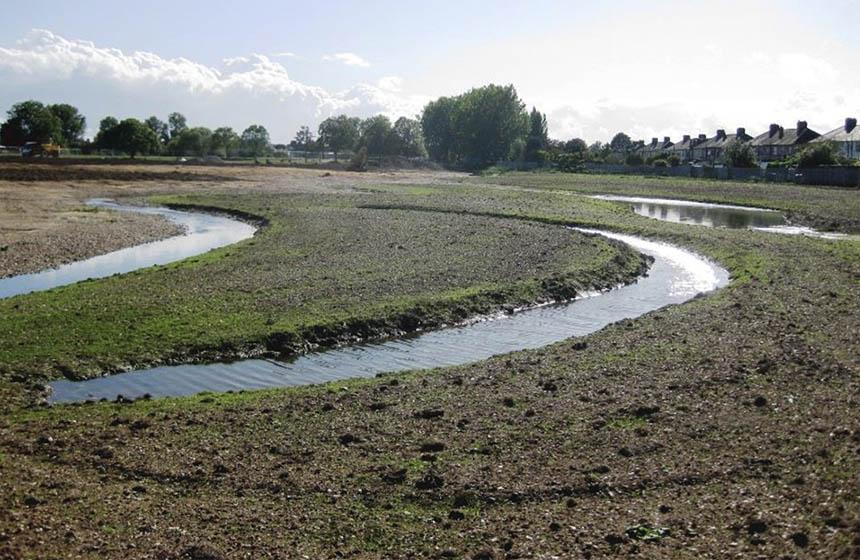
Mayesbrook Park is a 45 hectare park in East London which previously largely consisted of short-mown grass, and had become neglected and full of rubbish. During the creation of the park in the 1930s, the Mayes Brook which gave the park its name was diverted to run in a deep concrete channel along the west side of the park (1). This was fenced off and disconnected from the park, blocking the view of the river and limiting its function to a road drain and flood water channel (2). Flood risks were inadvertently increased, as an embankment formed by the accumulation of dredge from the brook lay at a higher level than adjacent properties, and two lakes created by the extraction of gravel and sand to build properties became heavily polluted by storm water overflow from the brook (3). In addition, many flood management assets on site (e.g. sluices, pumps) needed to be replaced. To address these risks and create a climate-resilient park for both people and wildlife, the river was brought back into the park and reconnected to the floodplain, treating it as an asset instead of a hazard. The project created 500 m of meandering channels to reduce high water flow, 450 m of graded river banks to increase river capacity, multiple sustainable urban drainage (SuDS) areas, 3 hectares of woodland, and 1.5 hectares of floodplain to facilitate floodwater storage (1,2). These initiatives also created attractive nature-rich green spaces for people and improved habitat diversity for wildlife, as well as making the park more resilient to droughts and helping to reduce the urban heat island effect. Local communities were engaged throughout the process, including through educational activities with school children, helping to promote local stewardship and a sense of pride in the area.
Overview of context:
The area was designated as an urban park in the 1930s, but development was halted in 1939 due to the start of the Second World War. Lack of maintenance and investment contributed to fears of crime and antisocial behaviour at the park, with fewer visitors (3), and in 2003 the London Borough of Barking and Dagenham Parks and Green Spaces Strategy identified the park as an area in need of rejuvenation (1). In 2007, as the masterplan to restore the site was being prepared by the Council, Thames River Restoration Trust, the Environment Agency and Design for London, the Mayes Brook site was also identified by the River Restoration Centre as having great potential to demonstrate natural flood management processes. This led to the focus on restoring the river in order to reduce flood and drought risk and provide more natural green spaces for park users.
Case effectiveness on
Climate change
Flat grass patches were converted into riparian woodland and acid grassland through local community planting. While data on the carbon sequestration benefits of restoration are not available, the ecosystem service assessment reported that only a marginal difference is expected due to tree growth and sequestration in floodplain soils (3).
The floodplain storage areas contributed an additional 15,800 m3 of flood storage capacity, reportedly reducing flood risk to residents in the neighbourhood (1). The created floodplain storage, woodland, and grassland is estimated to avert 26,729 m3 of rapid run-off per year (3). In addition, the wooded areas provide cooling and shading in hot weather (1).
Ecosystem health
Ecological effect: PositivePrior to the implementation of the restoration project, monitoring surveys in the brook found small chub, dace, and roach (3). Bat boxes were installed in poplar trees on site. In anticipation of the project, the mowing regime was relaxed, allowing for the growth of meadow grassland areas where there was once short, heavily mowed grass.
The restored river and floodplain hosts a complex patchwork of gravel riffles, runs, seasonal ponds, reed beds, acid grassland, and scrub vegetation (1). This reportedly provides habitat for species rarely sighted in this area of London, including freshwater fish, waterbirds, amphibians and bats (1). In addition, the 1 hectare of woodlands planted provides habitats for bird species in the London Biodiversity Action Plan, including the House Sparrow, Mistle Thrush, and Linnet (1). Around 40 percent of the park is designated as a Nature Conservation Area and a Site of Borough Importance Grade II, and one of the lakes with its surrounding lakeside vegetation, weeping willows, acid grassland and scrub habitat was designated as a Local Nature Reserve in 2005 (1). The project was accompanied by efforts to reduce water pollution at source, enabling one of the most polluted rivers in London to reach Good ecological status, and the swales and 1,000m² of reedbeds help to clean and filter run off from nearby roads and housing estates before it enters the river (1).
Socioeconomic outcomes
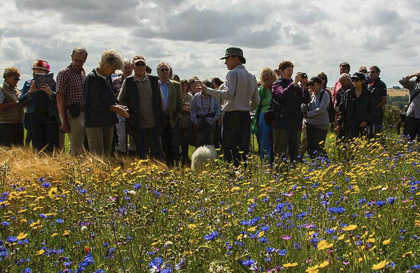
The park was developed in consultation with the local community. The views of children in three primary schools were consulted through the creation of artworks based on visits to the park (1). These artworks were then used during wider community engagement sessions. Other school engagement sessions included London Wildlife Trust’s project with Eastbury school to create an after-school club that encouraged children to engage with biodiversity within their schools and at the park, and Thames 21, Trees for Cities and Studio 3 Arts running curriculum-based sessions for students at the park. The natural play features and trail markers in the park were based on designs by local children.
Concerns were raised regarding safety in the park and the facilities available for use, as well as park maintenance (3). As such, the park masterplan included plans to enhance and connect footpaths, and create garden areas, changing facilities, a café, an interpretation centre and a base for park rangers. Although the gardens, café and interpretation centre have not yet been built due to lack of funding, the park now includes new signage, footpaths, an outdoor gym, adventure playground and multiple other sports and leisure facilities, and has received a Mayor of London Safer Parks Silver award for the high standards of safety and policing on site (5). Mayesbrook Park rangers and the London Wildlife Trust engaged local communities to look after and improve their park through the ‘Wild at Heart’ project (6). Consultation continues to receive suggestions to improve the park for the community.
Governance
Local participation in Governance: PassiveMulti-agency partnerships were formed to restore the park. From 2008, project partners included Thames Rivers Restoration Trust, London Borough of Barking and Dagenham, the Environment Agency, Natural England, the Greater London Authority, London Wildlife Trust, and Design for London (7). In 2011, the London Organising Committee of the Olympic Games joined this project. Local community views in the project were sought in the form of 2,000 questionnaires sent out in 2009, with a high proportion of responses received (1). Concerns regarding the provision of a welcoming and inclusive park were considered and added to the design of the project, e.g. through providing engagement activities and keeping sight lines open to improve security (1).
Finance
Phase 1 of the project cost £1,646,000 (1). This included a donation of £300,000 sought from an insurance company, RSA Ltd, by Thames Restoration Trust, £400,000 of funding through the Mayor of London’s Help a London Park scheme, a £150,000 contribution from Natural England’s ‘Access to Nature’ fund, £120,000 from the SITA Trust, and £120,000 contributed for the construction of ponds by the London Organising Committee of the Olympic Games (7). This broad partnership was brought together by combining the social goals of regenerating the area for people with the environmental goals related to climate resilience, flood risk and biodiversity, thus unlocking greater financial and human resources (1).
Funders were also motivated to contribute to the project due to the results of an Ecosystem Services Assessment conducted in 2010 by the Environment Agency and Queen Mary University of London (1) (3). This assessment estimated that ecosystem services gained through the restoration project, including health benefits, risk reduction, and cultural value provision, would result in a long-term return to society of £7 for every £1 spent. Benefits of the project are further demonstrated through reductions in estimated maintenance costs. Prior to construction, maintenance of the watercourse required £10,000 each year, but this was halved to £5,000 after restoration.
Monitoring and evaluation
A detailed monitoring plan was prepared during the design of the project by the River Restoration Centre and the London Borough of Barking and Dagenham (2) (8). Monitoring targets were set based on the SMART framework (Specific, Measurable, Achievable, Relevant, and Time based) to address four themes: climate change, aquatic environment, terrestrial environment, and people. Monitoring of all themes apart from the aquatic environment component was led by the London Borough of Barking and Dagenham. Between 2011 to 2013, a full-time ranger was appointed by the Council to collect data on habitat changes, species numbers and the resilience of the park and flora to climate change, as well as organising community programmes and coordinating volunteers. Information was also collected on the demographics of park visitors, volunteer participation, education opportunities, and public satisfaction.
The aquatic environment was monitored by a master’s student at Cranfield University alongside the Environment Agency from 2011 to 2013, by collecting data on geomorphology, river habitat, water quality, macroinvertebrate and macrophyte diversity and using fixed point photography. This was compared against baseline data from 2008 to 2009, finding that there was an increase in habitat types and their diversity, as well as river flow types. Macrophyte regrowth following construction was limited by drought-like conditions in 2011 and 2012. Fixed point photographs before, during and after construction (taken quarterly between spring 2011 and spring 2013) were scored based on the naturalness of riparian habitat and vegetation, resulting in peak scores after restoration.
Trade-offs and limitations
Large partnerships such as this project enable a diverse funding source and wider community engagement. However, this can also result in a multiplicity of goals for the project. Hence, the scope of the project had to be kept specific and tightly controlled so that core objectives were achieved (2).
References
- Natural England. 2013. Mayesbrook Park. Green infrastructure case study. https://publications.naturalengland.org.uk/publication/11909565
- Burgess-Gamble, L. 2017. Case study 2. Mayes Brook river restoration, Mayesbrook park, east London. https://www.therrc.co.uk/sites/default/files/projects/2_mayesbrook.pdf
- Everard, M., Shuker, L. and Gurnell, A. 2011. The Mayes Brook restoration in Mayesbrook Park, East London: an ecosystem services assessment. https://catalog.ipbes.net/system/assessment/193/references/files/568/original/The_Mayes_Brook_restoration_in_Mayesbrook_Park_East_London_-_an_ecosystem_service_assessment.pdf?1364316259
- Petrou, P. N.d. A feasibility assessment and a development proposal for an urban fishery in Mayesbrook Park, Barking. http://better-thames-network.westminster.ac.uk/files/Fishery_proposal_for_Mayesbrook,_Phillip_Petrou.pdf
- Barking & Dagenham. N.d. Mayesbrook Park. https://www.lbbd.gov.uk/find-your-nearest/mayesbrook-park
- London Wildlife Trust. N.d. Our projects. https://www.wildlondon.org.uk/projects
- The River Restoration Centre. Mayesbrook Climate Change Park. https://www.therrc.co.uk/sites/default/files/projects/p1279.pdf
- Restoring Europe’s Rivers. 2012. Mayesbrook Park adapting to climate change project monitoring strategy. https://restorerivers.eu/wiki/images/3/3d/Mayesbrook_project_monitoring_strategy_-_September_2012.pdf
Intervention type
- Created habitats
- Restoration
Ecosystem type
- Temperate forests
- Temperate grasslands
- Streams, rivers, riparian
- Urban
Climate change impacts addressed
- Air temperature
- Biomass cover loss
- Drought
- Freshwater flooding
Instigators
- State/district/local government agency
- Local NGO or CBO (eg. indigenous)
- National government/agency
Societal challenges
- Biodiversity conservation
- Climate change adaptation
- Conflict and Security
- Disaster risk reduction
- Water security
Outcomes
- Food security: Not reported
- Water security: Positive
- Health: Not reported
- Local economics: Not reported
- Livelihoods/goods/basic needs: Not reported
- Energy security: Not reported
- Disaster risk reduction: Positive
- Rights/empowerment/equality: Not reported
- Recreation: Positive
- Education: Positive
- Conflict and security: Not reported
- No. developmental outcomes reported: 5
Resources
Read resource 1Literature info
- Grey literature
Similar cases by ecosystem
-
River restoration and hillside stabilization near Swindale Beck
Restoring a historically straightened stream to its natural meandering path to slow the flow of water through the valley, reducing downstream flood risks and improving water quality, habitat creation, and biodiversity.
United Kingdom -
North East Cotswold Farmer Cluster: Landscape-scale nature recovery on farmland
The North East Cotswold Farmer Cluster is a network of farmers, growers, landowners, foresters, and advisors who share knowledge and collaborate on landscape-scale regeneration of farmed environments in the North East Cotswolds.
United Kingdom